
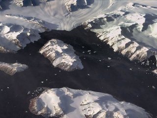
Space Technologies Institute of Scientific and Technological Research Council of Turkey (TUBITAK Space) shared images of Horseshoe Island and the surrounding area on Twitter.
TURKISH TEAM HAD TRAVELED TO ANTARCTICA
Rasat, literally meaning observation, can shoot satellite image everywhere in the world and transfers them to the earth station in TUBITAK Space. The images are used in cartography, disaster monitoring, smart agriculture, environment, and urban planning.


Earlier in February, a Turkish team traveled to Antarctica as part of the Third National Antarctic Science Expedition to spend 30 days, which was supported by the Turkish Presidency, the Industry and Technology Ministry, and Polar Research Center of Istanbul Technical University, along with other Turkish universities.


During the expedition, Anadolu Agency covered the team’s scientific efforts in Antarctica with a group of three journalists; economy correspondent Dilara Zengin, photojournalist Ozge Elif Kizil and cameraman Servet Ulku.
In April 2016, the first-ever Turkish team of researchers — including doctors, botanists, geologists, and oceanographers from seven universities — traveled to Antarctica to study the impact of climate change.
Antarctica, the coldest continent on earth, has served as a scientific research zone since the signing of a 1959 treaty.